


Published Aug. 2, 2013 | Link to original
Dear Friend and Reader:
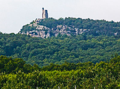
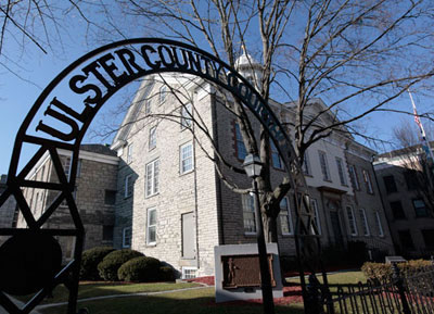
Nearly everyone who lives in the Hudson Valley of New York is familiar with the land preservation efforts of Mohonk Preserve. The name has a national reputation, synonymous with forests, trails and the most famous rock climbing area in the Northeast — the Gunks. The Preserve describes itself as the responsible steward of its land holdings, estimated at 8,000 acres and expanding constantly.
When lawsuits involving Mohonk Preserve (annual revenue: $3M) occasionally make the news, their standard response is that the Preserve, a New Paltz-based nonprofit, tax-exempt 501(c)3 corporation, buys only from willing sellers and rarely engages in litigation.
In that light, it’s noteworthy that in late May, State Supreme Court Judge Christopher E. Cahill issued a decision after a nine-year lawsuit that involved Mohonk Preserve claiming title to 75 acres of land that the court held actually belonged to its neighbors, Karen Pardini and Michael Fink. [You may download and read the full decision by Judge Cahill at this link.]
More noteworthy is that Mohonk and its land-acquisition agents have sued Pardini and Fink four times trying to take their land, keeping them tied up in nearly nonstop litigation and appeals for 19 years. In all that time Mohonk has never once won a case against them or had one upheld on appeal; their batting average is zero.
Pardini and Fink’s 300-acre property is the largest privately held undeveloped tract on the Shawangunk Ridge. Located directly in Mohonk’s viewshed and developable as a commercial property, Pardini and Fink’s land is surrounded by the Preserve, which has contested nearly every boundary the two neighbors share.
The Preserve started as the Mohonk Trust in 1963, when the Mohonk Mountain House, a for-profit resort hotel, put the majority of its land into a conservancy, thereby taking it off of the property tax rolls — and with that savings, helping the hotel avoid bankruptcy.
While Cahill’s ruling only addresses one property dispute, there are numerous similar situations that are currently developing. Mohonk variously claims to have between 100 and 250 neighbors along its perimeter, 28 of whom have signed an open letter to the Preserve objecting to its land-acquisition tactics, including the use of adverse possession or squatter’s rights as a means of acquiring property, something commonly done by Mohonk.
“We respect the property rights and boundaries of the Mohonk Preserve,” the letter states. “We now ask the Mohonk Preserve to publicly state their willingness to respect the property rights and boundaries of all of their neighbors.”
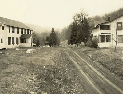
Smitty’s Bar and Dude Ranch
Many old-timers in the Hudson Valley remember Smitty’s Bar and Dude Ranch on Clove Valley Road. It was owned by Wilbur Smith, known to everyone as Smitty. For more than a generation, Smitty’s was the place to hang out by the stream, ride horses, camp and go hiking. The bar, located in an old barn, featured live music and dancing in a magnificent rustic setting. Regulars and staff stayed in a little hotel upstairs. Smitty patrolled his land on horseback wearing a revolver on his hip.
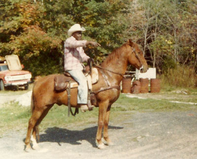
The place was a mecca for countless hippies and nature lovers from the 1960s until Smitty sold the property to Pardini and Fink in 1987. In the years before he sold the place he was under increasing legal pressures from Mohonk that dated back many years.
Toward the end of his ownership he was in foreclosure and Mohonk was circling like a great white shark.
Mohonk’s documents from that era indicate that they were urgently trying to get his land into the Preserve. Pardini and Fink came up with the funds to buy the place from Smitty, who went on to be a minister.
The couple closed the business and made a project of cleaning up the land from decades of overuse, removing old buses, trailers, campsites, dilapidated structures and 74 dump truck loads of trash and debris the first few years.
After nearly three decades of ownership, their only development of the property has been renovating the old bar and hotel into a home, and planting a garden. They have also maintained the labyrinth of trails and wood roads that spiral through the property, some of them dating back to before the American revolution.
The couple was first sued in 1994 by The Shawangunk Conservancy, which serves as a land acquisition agent of Mohonk Preserve. That suit unsuccessfully attempted to take 136 acres from them. State Supreme Court Judge Vincent Bradley said in his 1997 ruling on that case that Pardini and Fink had standing to bring a fraud action against the Conservancy. Had the Conservancy won, Mohonk said the land would have gone to them.
When I interviewed Mohonk’s longtime in-house surveyor, Norman Van Valkenburgh, about that lawsuit in 1997 as a reporter for Woodstock Times, he told me that he was after “the whole farm, whatever they [Pardini and Fink] own.”
He really meant it. For example, Pardini and Fink’s property includes about 200 acres on the north side of Clove Valley Road. In various lawsuits (including the most recent one), Mohonk or its agents have claimed every acre except for Smitty’s former house.
Fink said in a July interview that he and Pardini have spent more fighting lawsuits by Mohonk and its agents than they paid for the whole ranch. One can only imagine Mohonk’s legal bills.
Which is the Real King’s Lane Lot?
Land in the area where the lawsuit takes place is located within a land grant from 1770 called the Nineteen Partners Tract, which was subdivided into 19 sections or lots in 1799. [See map below — note that northerly is downward, opposite of a normal map.]
In 1841, the property boundary of a farm (called the Curran Farm) was drawn along a ridgeline laterally through Lots 1-5 and has not changed since. The Curran Farm may be forgotten, though a detailed history of its land transactions is lovingly preserved by the county deed office, tracking the details of title transfers going forward to the present.
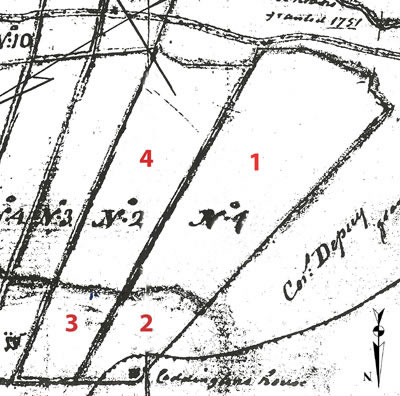
In Lot 1, the ridgeline currently divides the properties of Pardini and Fink (and the former Smitty’s Dude Ranch) from their neighbor, Gloria Finger. The lot is narrow and long. Finger owns the 26-acre tip at the north end of Lot 1, land known since the 1800s as the King’s Lane Lot, because an ancient road called the King’s Lane leads into it. The King’s Lane Lot was once part of the Curran Farm.
Pardini and Fink’s land includes 75 acres at the south end of Lot 1, on the other side of the ridge, close to Clove Valley Road. Their land was never part of the Curran Farm.
In 1994, Mohonk ‘purchased’ for $82,000 a deed for that 75 acres from Gloria Finger, falsely claiming it was the King’s Lane Lot. In other words, Mohonk bought the land from someone who didn’t own it. The transaction was arranged by Robert K. Anderberg, who served on Mohonk’s board of trustees from 1981-1987. He went on to become general counsel to both the Open Space Institute and the Shawangunk Conservancy.
Anderberg has purchased land from non-owners before. In an earlier land transaction that resulted in litigation, Anderberg posed as a notary and with Van Valkenburgh, ‘purchased’ land from Smitty’s ex-wife Mary Lue Smith long after her ex-husband had sold the ranch to Pardini and Fink.
Knowing that she used to hold deeds in her name for her husband, they told her she didn’t know she still owned some land somewhere up on the ridge and paid her $5,000 for a quitclaim deed, releasing any interest she might have to them. The Shawangunk Conservancy then sued Pardini and Fink, claiming the nonexistent interest as its own. That’s the case where the judge said the couple had standing to bring a fraud action.
Anderberg’s plan to acquire the 75 acres on Mohonk’s behalf dates back to a March 24, 1993 memo from Anderberg to Van Valkenburgh, and Glenn Hoagland, Mohonk’s executive director. In that memo, Anderberg writes, “One of the landowners on Rock Hill, a Gloria Finger, is interested in selling a portion of her acreage to the Mohonk Preserve.”
Testimony from other lawsuits indicates that Anderberg was acting in his capacity as general counsel to the Shawangunk Conservancy, the land acquisition agent for Mohonk.
To complete the ‘sale’, a survey map of the 75 acres of Lot 1 was prepared and certified by Van Valkenburgh, the longtime in-house surveyor for Mohonk, which in effect slices off a flank from Pardini and Fink’s land and claims it for Mohonk.
Finger ‘retained’ the 26 acres she really owned — she gave up no land in the deal.
Mohonk filed the map with the county and used it to get Planning Board approval for a subdivision from the Town of Rochester, ‘dividing’ the two sections of Lot 1 that have been separate since 1841. That is when the Curran farm boundary line was drawn, bisecting Lots 1-5; there have been different owners on either side of that line since it was originally drawn.
The same map was used to secure title insurance from First American Financial of Santa Ana, CA. Title insurance is a form of coverage that protects the buyer in case it turns out the purchased land was not actually owned by the seller. The Preserve then brought a lawsuit in State Supreme Court against the actual owners of the property, Pardini and Fink, attempting to get the courts to affirm what it claimed was “record title.” The litigation was paid for by First American, which now must either sponsor an appeal or reimburse Mohonk for its cost of purchase.
A First American spokesperson I spoke to in July had no official response but seemed surprised when I informed her that the company was the plaintiff, not the defendant. Title insurance carriers rarely prosecute lawsuits. They are usually the ones sued by others.
While it may seem that Gloria Finger tried to trick Mohonk into buying land that she didn’t really own, it was Anderberg — an attorney — who arranged the transaction on Finger’s and Mohonk’s behalf. This is apparently a routine activity for him. In a recent interview he told a reporter, “I’m involved with conservation transactions and dealing with landowners, many in Ulster County.”
Yet Fink says that Finger knew he and Pardini were the real owners of the land at that end of Lot 1. The King’s Lane Lot is landlocked; it has no road access except for the King’s Lane, which is more like a wide trail. Since she had no other way to get a car onto her property, Finger once approached Fink and Pardini to buy a right-of-way onto her acreage through Pardini and Fink’s portion of Lot 1. She ultimately withdrew the idea because the distance was too great and the terrain too steep to make a driveway practical.
Then two years later Finger ‘sold’ that same land, owned by Pardini and Fink, to Mohonk, collecting $82,000 that she reportedly used to cover the legal bills for a prior lawsuit against another neighbor, the Cabral family.
In trying to prove that a smaller 26-acre piece of land was a neighboring 75-acre tract, Mohonk presented conflicting theories that in effect attempted to rearrange the ownership history along that section of the Shawangunk Ridge.
Over nine years of litigation, the court heard from 30 witnesses (eight of whom were Mohonk’s), reviewed 100 exhibits and read 1,299 pages of trial testimony. After all of this, Judge Cahill ruled May 29 that Mohonk Preserve had no claim to the 75 acres in question.
The court rejected every single claim made by Mohonk Preserve and its attorney, John Connor of Hudson. It accepted every fact and argument presented by Pardini and Fink and their attorney, Sharon Graff of Kingston.
The Case of the Moving Mountain
As is true many places, rural land along the Shawangunk Ridge is often described in the deed record by the neighboring properties. These are called adjoiners. Once something is described by its relationship to adjacent lands in all directions, you know where it is and you can follow the deeds to who holds title in the present.
No two parcels of land have all of the same adjoiners; each is unique. This is why adjoiner descriptions are so dependable. Your land describes that of your neighbors; their land describes yours. Change any one adjoiner description and you have to rearrange the descriptions of every property in the area, since they all depend on one another.
It’s a little like turning a Rubik’s Cube. When you turn any one section, you simultaneously rearrange the patterns on four sides of the cube and shift the orientation of the other two. You cannot just move one square on the cube.
At the trial, Pardini and Fink pointed out that Mohonk failed to explain why its claim to the 75 acres was missing many necessary adjoiners and that it listed others not called for by the deed record.
One example involves land formerly owned by John I. Davis in the 19th century, now called the Davis parcel. The real King’s Lane Lot — the 26-acre one owned by Finger — calls for Davis as its eastern adjoiner.
But Mohonk claimed that Davis was next to the 75 acres owned by Pardini and Fink, which it is not. To do this, they had to pretend that the adjoiners for the real King’s Lane Lot would work simultaneously for that lot and for the 75 acres they were claiming, and where it really was. In other words, Mohonk claimed that the Davis parcel existed in two places at once.
In Van Valkenburgh’s survey of the 75 acres that was used to make the purchase and secure title insurance, he accurately lists Pardini and Fink as the eastern adjoiner.
Then in court, Mohonk tried to claim that the John I. Davis parcel was the eastern adjoiner to the 75 acres, in effect attempting to kick Fink and Pardini off of even more of their land. Davis is nowhere to be found in Pardini and Fink’s chain of title, for a good reason. The Davis parcel is located east of the real Kings Lane Lot, not the 75 acres that Mohonk was pretending was the King’s Lane Lot.
That Van Valkenburgh originally listed Pardini and Fink as the eastern adjoiner to the 75 acres in the survey used for the purchase and title coverage proves he knew Davis was not located there and that he knew who the real owners of the 75 acres were. Doing a survey involves researching the ownership history of each adjoiner. But he had another reason to know the real history: he had been surveyor and expert witness in every prior lawsuit against Pardini and Fink. There are documents in the record demonstrating that Van Valkenburgh has researched the ownership of Lots 1 through 5 back to the dawn of time; he knows exactly who owns them.
At trial, Mohonk failed to present a witness who had actually done a survey of the property it was claiming. Notably, Van Valkenburgh was not called as a witness by Mohonk to tell the story of his survey, which would be pro forma — an expert testifies to the technical work he’s done. Instead, he sat in court nearly every day of the trial and assisted Mohonk’s legal team.
Had he been called as a witness, Pardini and Fink’s lawyers would have asked him to explain how the Davis parcel got up and walked down the mountain.
As for the King’s Lane, the ancient road which seems curiously left out of this whole saga: it follows the ridge along the Curran Farm boundary, leading into the King’s Lane Lot itself — along the north end of the ridgeline and the John I. Davis parcel, far from Pardini and Fink’s land. Its place on the landscape and in history is undeniable.
Presented with these and other facts, Judge Cahill concluded that Finger never owned the land Mohonk had ‘purchased’ from her, and ruled that Pardini and Fink hold both proper title and common law possession of their land, calling theirs the “more coherent” of the two descriptions of ownership history, current title and usage — an understatement on the judge’s part.
In late July, I went to Mohonk Preserve to interview its top leaders — Glenn Hoagland, the executive director, Ronald Knapp, the board president, and Gretchen Reed, a lawyer who serves as the Preserve’s publicist.
They spent an hour and 20 minutes attempting to convince me that it was really Michael Fink who was trying to take their land from them. Mohonk’s execs also claimed that Pardini and Fink didn’t believe they owned the 75 acres that the judge determined were part of the couple’s own property. This is where the interview started to feel like a Saturday Night Live sketch.
Fink and Pardini didn’t believe they owned it? That’s what they said — the logic here being: they didn’t know they owned it, so we claimed it. Or, we claimed it before they claimed it. Or we filed a map that they didn’t know about, so that makes it ours.
Throughout the meeting, none of the Preserve’s officials would answer any of my questions about why the adjoiners to the land to which they were claiming to hold a deed did not match known reality on the ground.
They claimed not to remember the details and said they didn’t want to “re-litigate” the case in their conference room. They put out enough spin to make it sound like there was another side to the story — one that they could not explain or support factually.
Mohonk recently said that its board of directors had voted to appeal Cahill’s ruling. In a July 5 letter to the Preserve’s members and supporters, Hoagland and Knapp claimed that Mohonk still owns the 75 acres. They trivialized Judge Cahill’s decision as being just three pages long when in fact it’s 90 pages, most of it straightening out the deed history in accordance with what Pardini and Fink’s attorney had presented at trial.
Hoagland and Knapp wrote, “The continuing litigation […] underscores the importance of the Preserve’s critical land protection work, which deals not only with acquisition of land and conservation easements but with the perpetual protection of lands in our care. With your continued support, we will remain steadfast in our 50-year heritage of saving the land for life.”
Sure sounds good.
Lovingly,
For the Grandmothers.